Mapping bee food availability on Réunion island using open data
Context
Symbiome developed for Bee Run Apiculture an interactive mapping application to visualise food availability for bees across Réunion island. The project is part of an ecological initiative: using bees as bio-indicators to guide the revegetation of urban areas.
Bee Run Apiculture wanted to combine data from their connected hives (temperature, weight, colony activity…) with open geospatial data sources: land cover maps, urbanisation data, a melliferous flowering calendar, and meteorological data. The goal: build a dynamic, synthetic tool to guide urban revegetation.
Monitorun, the interactive map
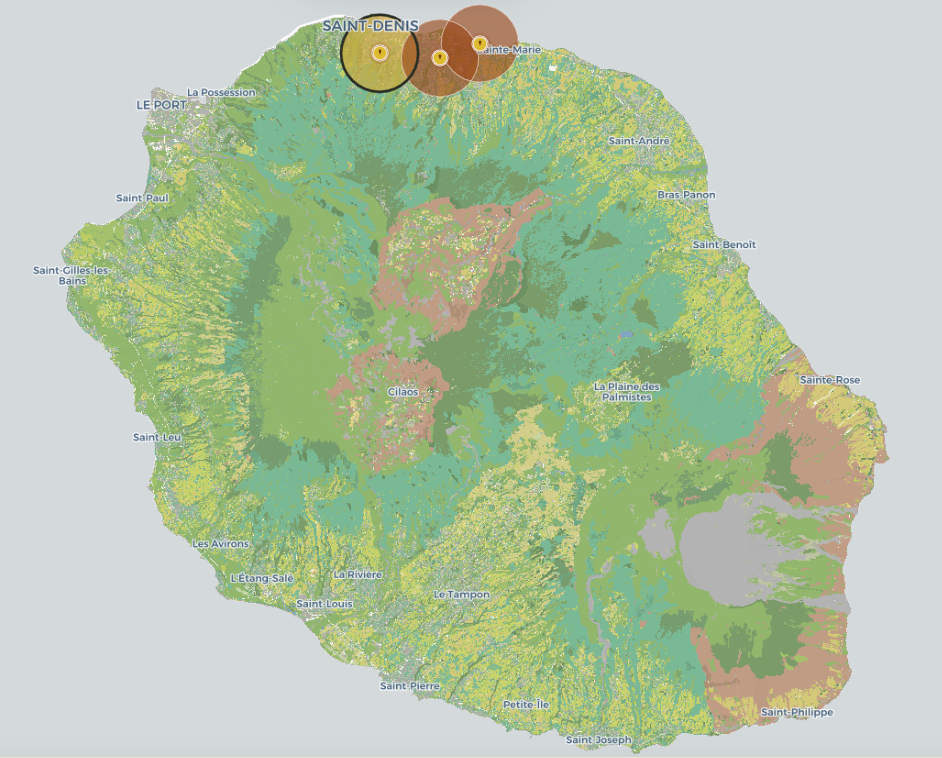
Monitorun is the tool developed as part of this project. It provides an interactive map of Réunion island bringing together all the data sources mobilised, accessible online on the Bee Run Apiculture website.
Exemple de carte produite pour cartographier l'habitat butinable
Development of Monitorun, an interactive web application combining connected hive sensor data with open geospatial and climate data sources to map bee food availability across Réunion island.
🛠️ Key technologies
Python, MapLibre, Django
Data sources used
Données des ruches — Bee Guard — Ruches connectées mesurant en continu le poids, la température et l'activité de la colonie. Données fournies par Bee Guard dans le cadre du réseau Bee Run Apiculture.
Habitats naturels CarHab 2026 — Cartographie nationale des habitats naturels et semi-naturels. MEDDE, OFB, IGN, Réseau des Conservatoires Botaniques Nationaux, EVS UMR 5600 CNRS, Patrinat.
Végétation & couvert arboré — Nature en Ville, IGN 2022. Végétation basse permanente et couvert arboré.
Espaces urbanisés — Tache urbaine, DEAL Réunion 2025. Direction de l'Environnement, de l'Aménagement et du Logement de La Réunion.
Limite terre-mer — BD TOPO® Express, IGN 2025.
Calendrier des floraisons mellifères — J. Triolo, ONF Île de La Réunion, 2009. Miels, ruchers et plantes endémiques dans les forêts publiques. Étude financée par la DIREN Réunion.
The Results
Monitorun provides a geolocated, dynamic view of bee food availability across the whole island. By combining connected hive data with environmental and climate data, the tool identifies areas with high foraging potential and areas to prioritise for revegetation.
🐝 A data-driven tool for urban revegetation.
By positioning bees as bio-indicators, Bee Run Apiculture is driving a data-driven urban revegetation initiative across Réunion island.